Hayle Neighbourhood Plan
Selected extracts (with editor's highlights) you're recommended to check the document for yourself:
Important Villages -- Angarrack and Phillack
1.6 Adjacent to Hayle, lying within the parish boundary, are the two villages of Angarrack and Phillack. Angarrack preceded Hayle’s development in that the first tin smelter was built there in 1704. Angarrack has its own industrial heritage including the steep incline of the Hayle Railway that required the wagons to be hauled up by ropes – now identified as Steamers Hill - and the stunning viaduct that spans the settlement. This was built by Isambard Kingdom Brunel, initially in timber and later rebuilt in granite. With its inland valley setting, Angarrack is a village clearly separate from the expanding Hayle. The Neighbourhood Plan seeks to continue to protect it from encroachment.
[Extract from page 4/ PDF page 6]
...
"
Development within Built-up Areas
The Local Plan sets out a minimum amount of housing development that should be provided in and around Hayle in the period until 2030. National planning policy states that a neighbourhood plan cannot reduce this scale of development. If we are to have a plan for Hayle, it must understand and respond positively to the implications of this scale of development. We have, however, an opportunity to help ensure that this development happens on our terms and is brought forward in a way that assimilates what Hayle is like to live and work in.
While we support the principle of Hayle accommodating development consistent with that set out in the Local Plan, we are clear that this cannot mean development at any cost, or in any location. With the sensitive environmental areas surrounding Hayle and its status as a World Heritage Site, we need to be careful not to allow development in inappropriate locations that could compromise the high - quality local natural and built environment. Consultation has clearly supported this position. For example, the Community Consultation of 2016 showed that 98% of respondents support measures that protect and or enhance the unspoilt and undeveloped coastal environment, 93% support development where it is in keeping with its setting, and 92% want to ensure development contributes positively to maintaining the distinctiveness of the area’s different settlement areas.
We are not allocating development sites in this Plan to accommodate the scale of development required by the Local Plan. Suitable sites need to be identified for that growth. We shall continue to work closely with Cornwall Council as it develops the Site Allocations Development Plan Document (DPD), which will identify the larger scale development sites 22 for housing in the Hayle area. These should be contiguous with the edge of Hayle and the DPD will need to take into account the evidence behind our Plan and its policies.
Outside of any large - scale development locations, we also need to set the scope of where is, and is not, an acceptable location for windfall development 23 to take place. National policy supports this intent stating that the “ planning system should contribute to and enhance the natural and local environment by protecting and enhancing valued landscape ...” (NPPF para. 109). The NPPF makes clear distinctions between built up areas and the countryside. A clear definition of a built - up area boundary will help distinguish between the built - up areas where sustainable development is acceptable in principle and the surrounding countryside.
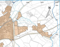
Map 3 defines built - up area boundaries for Hayle, Harbour, Phillack and Angarrack. The boundaries have been drawn to encompass all areas that are developed (at October 2017) and considered to be part of the settlement area. Areas outside of the built - up areas are regarded as countryside and subject to countryside policies. We recognise that some of this land has extant planning permission for major development and other land will be identified for strategic growth development in Cornwall Council’s Site Allocations DPD. If, and when, these major developments have been completed they too should be considered as part of the built - up area.
By establishing built - up areas, we will afford some protection to the countryside areas adjacent to the built - extent of Hayle, we have set a development limit boundary. It will help to prevent the sprawl of Hayle outwards and ensure that the focus of any windfall development takes place in Hayle. These same principles are also behind setting built - up area boundaries for Phil lack and Angarrack. To strengthen our position on defending the built - extent of Phillack and Angarrack, we have also introduced policy NE1 Local Gaps. The built - up area boundaries are defined on Map 3.
[Extract from page 25 / pdf page 27]
....
POLICY SD1 Development within Built - up Areas
Hayle, Harbour, Phillack and Angarrack built - up area boundaries are defined on Map 3 within which the principle of development is supported.
The built - up area represents the preferred location for new, small - scale development sites, whilst recognising that sites for additional “strategic” housing development may need to be allocated contiguous to this boundary (where they have no adverse impact on Hayle’s heritage assets or designation as a World Heritage Site) by the local planning authority during the plan period.
[Extract from page 27 / PDF page 29]
.......
7.12 The land use policies that follow are intended to ensure that future development in the Hayle
neighbourhood area helps meet our objectives.
Local Gaps
We have indicated the importance of the local countryside and the need to keep sprawl of the
settlements to a minimum by introducing a built-up area boundary policy SD1 for Hayle, Angarrack and
Phillack, with a focus on new development being in Hayle and on its built edge. However, we are keen
to reinforce this principle with a specific policy that seeks to maintain a buffer or ‘local green gap’
between both Phillack and Angarrack and Hayle, specifically to prevent coalescence. The principle of a
buffer to prevent coalescence or urban sprawl and protect the integrity of the settlements was raised
in comments received during our Aims and Objectives Consultation in 2015. The need to prevent
coalescence is recognised in the Hayle Heritage and Character Assessment, which states that “the
character assessment has identified that the open countryside which provides the setting of Hayle and
prevents its coalescence with surrounding settlements is sensitive to change and a key characteristic of
the area”33 (page 59). This evidence reinforces restrictions placed on development in areas around
Phillack and Angarrack by previous planning policies.
The Penwith Local Plan (2004) identified a number of areas around the settlements in its policy TV2
protecting the ‘local environmental value.’ Our policy NE1 on local gaps extends these areas to create
wider buffers specifically to prevent coalescence and provide an open break between settlements so as
to maintain character and identity. Our policy NE7 identifies particular pockets of land, some within the
local gaps, which require additional protection by virtue of their quality as green infrastructure.
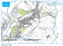
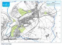
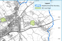
The local gaps are shown on Map 8. Proposals in these areas will only be supported for uses or
development that are essential because of their location or need on the site proposed. Notwithstanding
this, proposals that qualify for development in these local green gaps must not take place at the expense
of the quality of the landscape or setting. Our policy NE1 seeks to ensure this is taken fully into account.
POLICY NE1 Local Gaps
To ensure that Phillack and Angarrack maintain their separate identity, setting in the
landscape and local built character and extent, a local green gap (as identified on Map 8) will
be maintained to prevent coalescence between:
i) Phillack and north east of Hayle and Riviere Towans;
ii) Angarrack and the east of Hayle and Marsh Lane employment area; and
iii) Foundry and developments to the south and west.
Proposals for development will only be supported where they:
i) are for measures to prevent coastal erosion or flooding; or,
33 See http://np.hayle.net/wp-ads/2013/10/Hayle-Heritage-and-Character-Assessment-HR-160512.pdf
ii) propose improvements to access to the countryside; or,
iii) are for essential agricultural uses; and,
iv) do not compromise the visual openness and landscape character of the gap; and,
v) do not compromise the character or setting of important international, national and
local heritage assets.
[Extract from page 47/ PDF age 49]
[All extracts from http://www.hayletowncouncil.net/wp-content/uploads/2018/05/20180528-Hayle-Neighbourhood-Plan-FINAL.pdf]
- Printer-friendly version
- Login or register to post comments
- Visit Hayle Neighbourhood Plan
- Permalink
Contributions
- Angarrack Defibrillator Team (25)
- Angarrack Inn (336)
- Angarrack Methodist Chapel (3)
- Carol (15)
- Gail (1)
- GordonG (12)
- Hayle Development Group on Facebook (5)
- Hayle Harbour Authority (4)
- Hayle Town Council (5)
- louise (1)
- Lynne (94)
- Mal (1)
- Neil (22)
- Neils Garden Care (9)
- Russell (21)
- Secretary - Christmas Lights (118)
- Steve (3)
- webmaster (5022)
Facebook - Hayle Neighbourhood Plan
Book page
Similar
- Adopted Hayle Neighbourhood Plan - June 2018
- 1709 | Highway Plans
- Approved with conditions | Decision Notice | PA16/03519 | Erection of retail development (Class A1)
- 160401 | Possible expansion on northern edge of Angarrack | Hayle Neighbourhood Plan | Policies - First Consultation
- Cranford Developments - Marsh Lane
Similar across site
- Adopted Hayle Neighbourhood Plan - June 2018
- 1709 | Highway Plans
- Approved with conditions | Decision Notice | PA16/03519 | Erection of retail development (Class A1)
- 160401 | Possible expansion on northern edge of Angarrack | Hayle Neighbourhood Plan | Policies - First Consultation
- Cranford Developments - Marsh Lane
Hayle and Angarrack news | Google
- Hayle set to host various finals | cornish-times.co.uk - The Cornish Times
- Hayle North Quay collapsed company Sennybridge leaves £135 million debts - Cornwall Live
- Latest News From Hayle - Breaking News & Stories - Cornwall Live
- A30 Traffic Today - News on Accidents, Crashes & Closures - Cornwall Live
- Much loved dad in fatal crash was three times over drink drive limit - Cornwall Live
- Cornwall death notices this week including beloved mums - Cornwall Live
- Cornwall death and funeral notices this week including two beloved mums - Cornwall Live
- Cornwall death and funeral notices this week including two beloved mums - Cornwall Live
- Cornwall death and funeral notices this week including two beloved mums - Cornwall Live
- Cornwall death and funeral notices this week including two beloved mums - Cornwall Live
- Cornwall death and funeral notices this week including two beloved mums - Cornwall Live
- Cornwall death and funeral notices this week including two beloved mums - Cornwall Live
Problems within 7km of Hayle | FixMyStreet
Hayle News
- Hayle set to host various finals | cornish-times.co.uk - The Cornish Times
- A post from Hayle Town Council
- A post from Hayle Town Council
- *Road Closure Order - St Johns Street, Hayle* Road Traffic Regulation Act 1984 S.14: Temporary Prohibition of Traffic: Locati...
- *Road Closure order - Foundry Lane, Hayle* Road Traffic Regulation Act 1984 S.14: Temporary Prohibition of Traffic: Location:...
- *Road Closure order - Carnsew Road, Hayle* Road Traffic Regulation Act 1984 S.14: Temporary Prohibition of Traffic: Location:...
- Hayle North Quay collapsed company Sennybridge leaves £135 million debts - Cornwall Live
- www.hayletowncouncil.net
Facebook - Hayle Town Council
- A post from Hayle Town Council
- A post from Hayle Town Council
- *Road Closure Order - St Johns Street, Hayle* Road Traffic Regulation Act 1984 S.14: Temporary Prohibition of Traffic: Locati...
- *Road Closure order - Foundry Lane, Hayle* Road Traffic Regulation Act 1984 S.14: Temporary Prohibition of Traffic: Location:...
- *Road Closure order - Carnsew Road, Hayle* Road Traffic Regulation Act 1984 S.14: Temporary Prohibition of Traffic: Location:...
Facebook - Hayle and St Ives Police
- DO YOU KNOW WHO DID THIS?? Someone has sprayed this terrible graffiti on the wa...
- KEEP YOUR SHED AND GARAGE SAFE!!!! Although here in West Cornwall we live in a r...
- We have been asked to share this post. It serves as a horrific warning about the...
- http://m.westbriton.co.uk/Thieving-neighbour-lives-hell/story-26538405-detail/st...
- Serious RTC A30 Chiverton Cross. Witnesses sought after A30 collision, near T...
- Missing man Andrew Lambert found safe Found in Oxfordshire A man who went miss...


Recent comments
1 day 10 hours ago
35 weeks 5 days ago
37 weeks 3 days ago
37 weeks 3 days ago
47 weeks 1 day ago
1 year 7 weeks ago
1 year 32 weeks ago
1 year 42 weeks ago
2 years 2 weeks ago
3 years 26 weeks ago